
Deep dive · Geography
Earthquakes: why the Earth shakes, and how we stay safe
The ground we walk on feels firm and steady. But now and then, for a few seconds, that same ground starts to shake: pots rattle, fans swing and people rush outside in panic. That is an earthquake. Here you can cut the Earth open and look inside, see this week's earthquakes around the world on a map, make an earthquake yourself in the simulator to see how big the gap is between a 5 and a 7, and learn how to keep yourself and your loved ones safe when one comes.

After this you can explain
- what layers lie inside the Earth, and how scientists identified them without digging;
- what plates are, and why most earthquakes happen at their boundaries;
- what the focus and the epicentre of an earthquake are;
- how P, S and surface waves travel, and how three stations find where an earthquake struck;
- how much difference there is between a magnitude 6 and a magnitude 7 earthquake, and why intensity is something else;
- how great the earthquake risk is in different parts of India and Rajasthan;
- how a tsunami forms, and why it races so fast across the sea;
- what to do, and what not to do, during and after an earthquake.
Progress is kept only in this browser. Nothing is sent anywhere.
1Inside the Earth: layer by layer
The Earth is made of layers, like an onion. On top is the thin crust, where we live. Below it lies the very thick mantle, and right in the middle is the core of iron and nickel, whose outer part is liquid and inner part solid. The distance to the centre of the Earth is about 6,371 kilometres.
Nobody has dug that deep to look. The deepest hole people have ever made is the Kola Superdeep Borehole in Russia, and it reached only about 12 kilometres. That is not even one five-hundredth of the way to the centre. So how did scientists find out what is inside? From earthquake waves. Every big earthquake sends waves right through the Earth. Stations around the world record which waves arrive, when and how strongly, and from this the inner layers were worked out, just as doctors see inside the body with an X-ray.
Shadow zone
In a band on the far side of the Earth, between 104° and 140° from the earthquake, no direct P waves are recorded. The waves enter the liquid outer core and bend, and this band is missed. S waves reach nowhere beyond 104°, because an S wave cannot travel through liquid at all. This is how we learned that the outer core is liquid.
Moho
At the boundary between the crust and the mantle, the speed of the waves suddenly jumps. The Croatian scientist Andrija Mohorovičić found it in 1909 by reading the waves of an earthquake, so it is called the Moho.
Solid inner core
Inside the liquid core there is also a solid ball. The Danish scientist Inge Lehmann pointed this out in 1936. She noticed that faint echoes of P waves were reaching even the shadow zone, and they could only have come from bouncing off some solid layer deep inside.
Checkpoint✓ Stop complete
1Which layer of the Earth is liquid?
S waves do not pass through the outer core, and an S wave cannot travel through liquid. This is how we learned that the outer core is liquid.
2How did scientists identify the layers inside the Earth?
Even the deepest hole has gone only about 12 kilometres. The layers were identified from the speed and paths of seismic waves.
3The inner core is very hot, so why is it solid?
The higher the pressure, the more heat a substance needs to melt. At the centre of the Earth the pressure is so great that iron stays solid even though it is hot.
2Plates: the Earth's broken shell
The Earth's topmost rigid layer, that is, the crust together with the cool, rigid part of the mantle just below it, is called the lithosphere. This layer is not one unbroken shell. Like a cracked eggshell, it is split into many large and small pieces called tectonic plates. There are seven big plates and many small ones.
These plates move as if floating on the hot, slowly flowing mantle below, a few centimetres a year, about as fast as our fingernails grow. In some places two plates move apart, in some they collide, and in others they grind past each other side by side. Where plates meet, the rocks are under the most stress, and that is why most of the world's earthquakes happen along these boundaries.
Divergent: plates move apart
Where two plates move apart, molten rock rises through the crack between them and forms a new layer. Most such boundaries lie in the middle of the oceans, like the long mountain range down the middle of the Atlantic Ocean. Earthquakes here are usually small and shallow.
Convergent: plates collide
Where plates collide, one plate can sink beneath the other, or both can crumple and push up mountains. The world's biggest earthquakes happen at boundaries like these. A ring of such boundaries runs around the Pacific Ocean; it is called the Ring of Fire, because there are many volcanoes there too.
Transform: plates slide past
Where two plates slide past each other in opposite directions, the rocks move in jerks, sticking and slipping. The San Andreas Fault in California, USA, is a boundary of this kind.
India's plate heads north
The plate India sits on has been moving north for tens of millions of years and is colliding with the Eurasian plate. This collision raised the Himalayas, and it is still going on today. That is why the whole Himalayan region is at risk of big earthquakes.
Checkpoint✓ Stop complete
1Where do most of the world's earthquakes happen?
Where plates meet, the rocks are under the most stress. On the map, this week's earthquakes also cluster along these boundaries.
2The collision of which plates made the Himalayas?
India's plate is moving north and colliding with the Eurasian plate, and this collision is still going on today.
3About how fast do plates move?
About as much as our fingernails grow in a year. But over tens of millions of years, this slow movement carries continents thousands of kilometres.
3How an earthquake happens
Rocks are not completely rigid; when pushed, they bend and stretch a little, like rubber. The plates keep moving, but where two blocks of rock meet, friction keeps them stuck. Year after year the stress builds up, like a bowstring drawn tighter and tighter. One day the stress grows bigger than the friction, the rock suddenly slips along a crack, and the stored energy spreads out in all directions as waves. That is an earthquake. Harry Fielding Reid explained this after the 1906 San Francisco earthquake; it is called the elastic rebound theory.
The crack along which the rocks slip is called a fault. The point inside the Earth where the slipping begins is the focus, or hypocentre. The spot on the surface directly above it is the epicentre. The place the news reports is the epicentre.
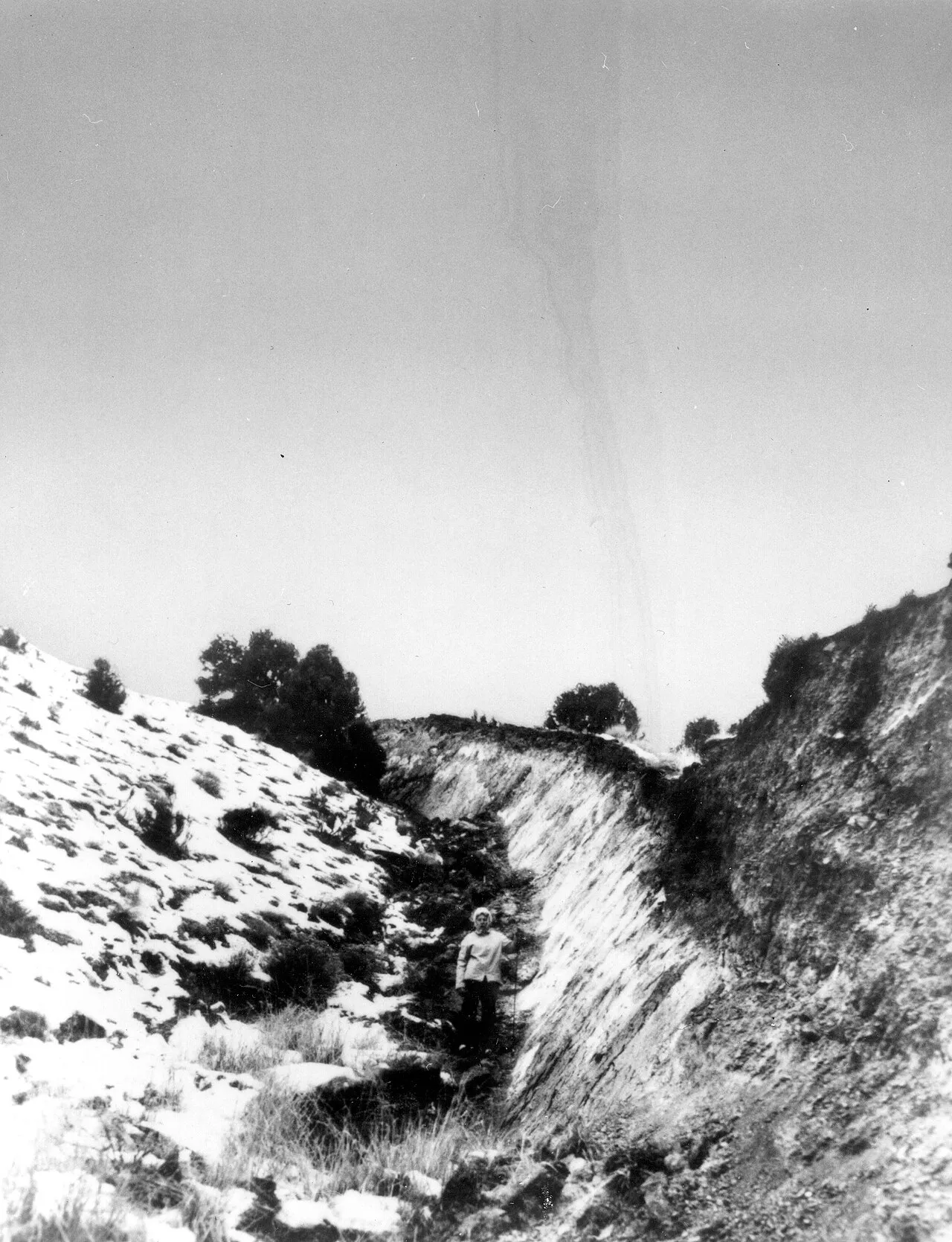
Nevada (USA), 1954: In the earthquake of 16 December 1954 the ground slipped along a fault near Fairview Peak and left this steep wall. It is called a fault scarp. Use the person standing at its foot to judge its height.
Photo H. Benioff; USGS Earthquake Information Bulletin, vol. 6, no. 6 (1974). Public domain. Image: Wikimedia Commons.

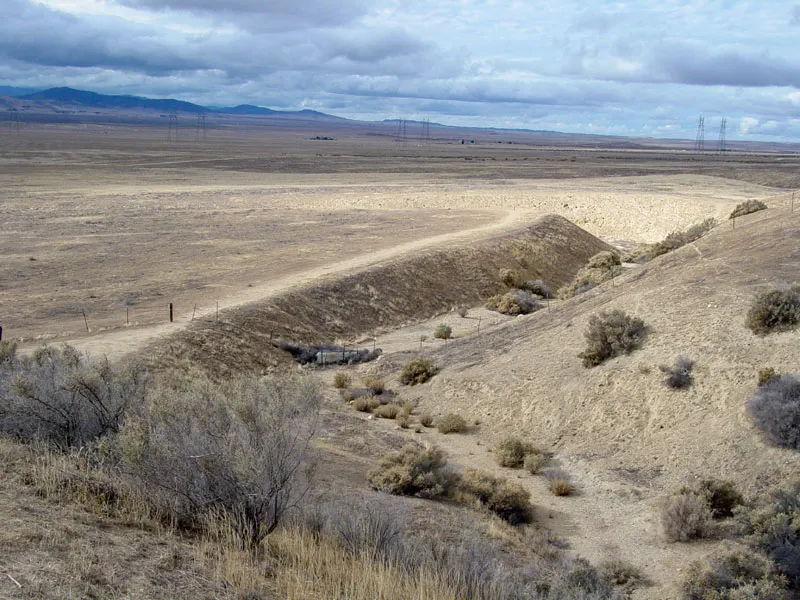
Wallace Creek, California: This stream crosses the San Andreas Fault and bends sharply where it meets the fault. The ground on the two sides of the fault kept sliding sideways past each other, and the downstream part of the stream moved along with it. In about 3,700 years the offset has reached roughly 130 metres, not in one earthquake but in many.
USGS. Public domain. Image: Wikimedia Commons.

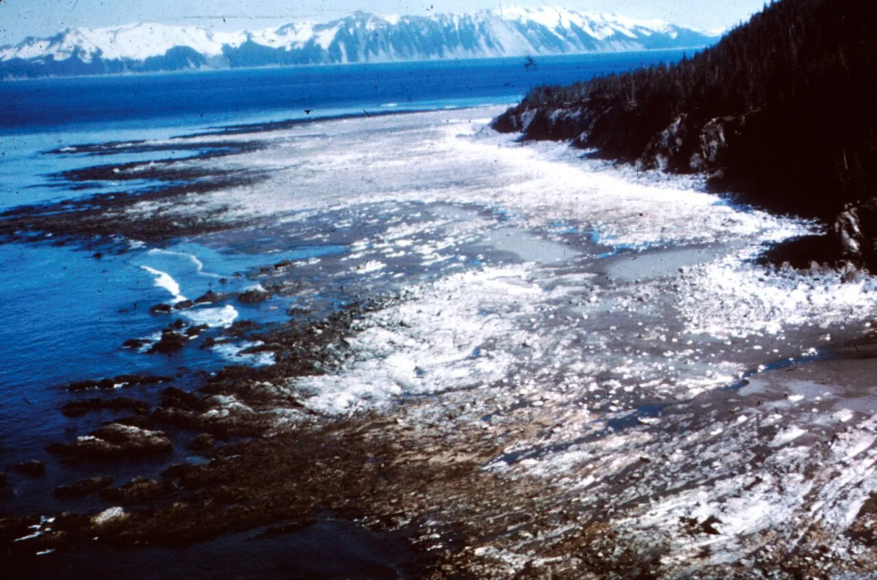
Alaska, 1964: In the 1964 Alaska earthquake the coast of Prince William Sound was lifted up. A flat rock shelf that used to lie under the sea now stands above the water.
USGS. Public domain. Image: Wikimedia Commons.

How deep?
If the focus is less than 70 kilometres deep, the earthquake is called shallow; at 70 to 300 kilometres it is intermediate-depth, and from 300 to about 700 kilometres it is deep. Shallow earthquakes happen close to the surface, so they do more damage than a deep earthquake of the same magnitude.
One earthquake, many shocks
After a big earthquake the rocks around it settle again, and small shocks keep coming for days, weeks, sometimes months. These are called aftershocks. Sometimes small shocks come before a big earthquake too, but at the time nobody can tell that a big one is on its way.
Checkpoint✓ Stop complete
1What is the epicentre?
The place inside is the focus. The epicentre is on the surface directly above it.
2What kind of faults are common in the Himalayas?
In a collision the rocks are under compression, and the upper block climbs up the fault plane.
3Of two earthquakes of the same magnitude, which will cause more damage at the surface?
A shallow earthquake is close to the surface. The waves of a deep earthquake grow weaker by the time they reach the surface.
4Seismic waves
The energy of an earthquake spreads out as waves, like the ripples when you throw a stone into a pond. These seismic waves are of two kinds. Some travel through the inside of the Earth: these are body waves, P and S. Others travel only along the surface: these are surface waves.
The P wave (primary wave) is the fastest and arrives first. It pushes and pulls the rock back and forth as it goes, like a pulse of squeezing along a spring. It can travel through solids, liquids and gases. The S wave (secondary wave) comes after it. It shakes the rock up and down or side to side, like the wave when you flick a rope. It travels only through solids. Surface waves are the slowest, but they shake the ground the most, so they cause the most damage.
P first, S later
The P wave travels about 1.7 times faster than the S wave. So the farther away the earthquake, the bigger the gap between their arrivals. One station tells you only the distance, not the direction; so to find the place you need at least three stations.
Seismograph
The machine that records the shaking of the ground is a seismograph, and the wiggly line it draws is a seismogram. In old machines a heavy hanging weight stayed still while a pen drew a line on paper that moved with the ground. Today electronic sensors do this job.
Checkpoint✓ Stop complete
1Which wave reaches a station first?
The P wave is the fastest, about 5 to 7 kilometres per second in the crust. That is why it is called Primary, meaning first.
2Why does the S wave not pass through the outer core?
An S wave shakes rock across its path, and in a liquid that kind of motion does not travel on.
3At a station the S−P gap is 20 seconds. About how far away is the earthquake?
Rough rule: about 8 kilometres for every second of gap. 20 × 8 = 160 kilometres.
5Earthquake simulator: magnitude and intensity
An earthquake is measured in two ways, and the two tell you different things. Magnitude tells you how much energy the earthquake released at its source. An earthquake has only one magnitude, wherever you are. Intensity tells you how strongly the ground shook at one particular place and what damage was done there. The same earthquake has a higher intensity near the epicentre and a lower one far away. Think of a bulb: how many watts the bulb is, that is magnitude; how much light falls on your desk, that is intensity.
The magnitude scale is not linear but logarithmic. One step up the scale makes the wave on a seismogram 10 times taller, and the energy released about 32 times greater. So a magnitude 7 earthquake makes a wave 100 times taller than a magnitude 5, but releases about 1,000 times more energy. Try it yourself in the simulator below.
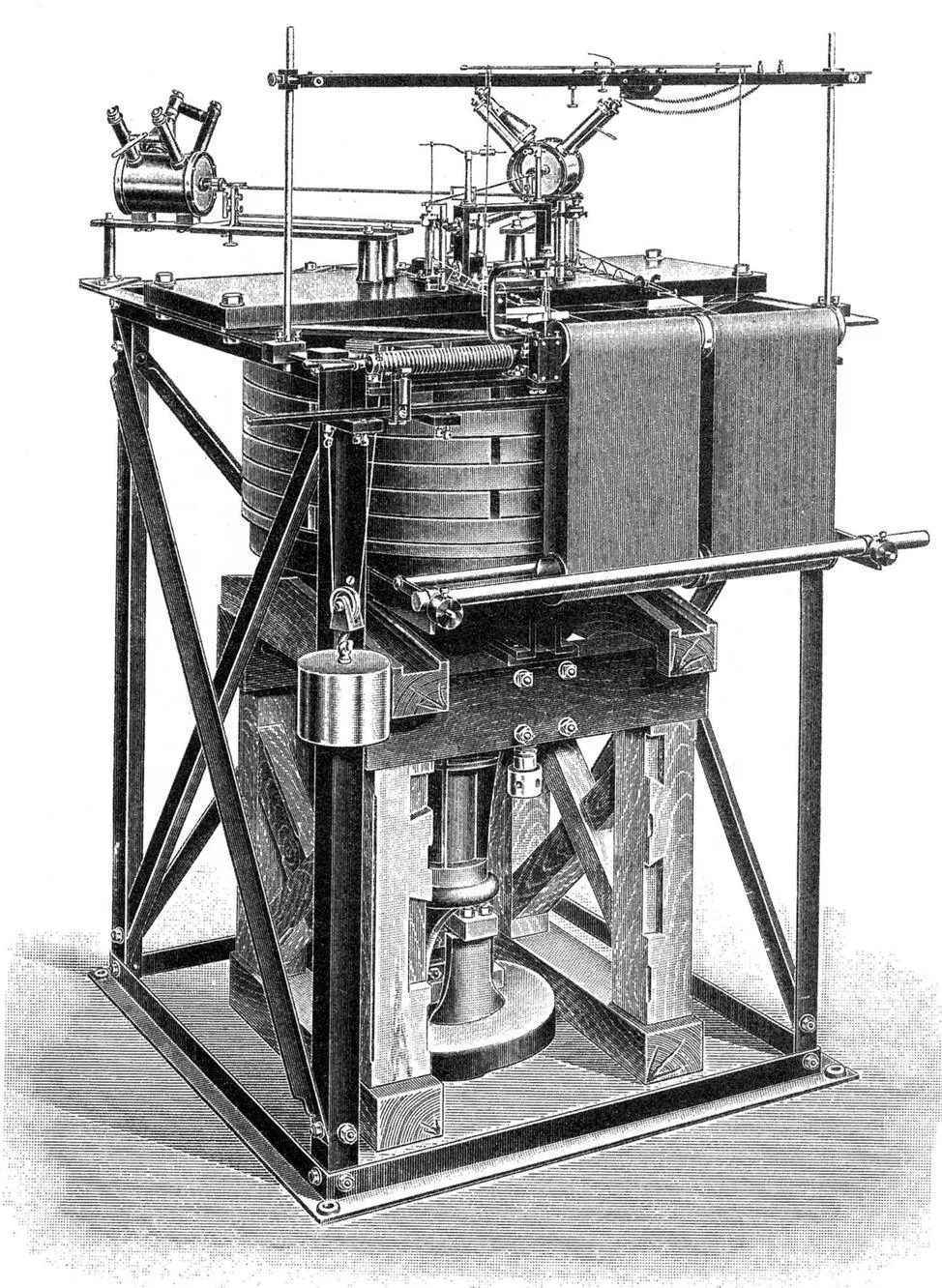
Wiechert’s seismograph: A seismograph designed by the German scientist Emil Wiechert, in a drawing from a 1914 book. The heavy mass in the middle tends to stay where it is while the frame moves with the ground. Levers magnify the difference between the two, and it is recorded as a line on paper.
Drawing in B. Galitzin, Vorlesungen über Seismometrie (1914). Public domain. Image: Wikimedia Commons.

What happened to the Richter scale?
In 1935 Charles Richter made the local magnitude (ML) scale for earthquakes in California. It cannot measure very large earthquakes properly. Today scientists use moment magnitude (Mw), which depends on how big the fault was and how far it slipped. For moderate earthquakes the two give roughly the same number, so you still hear “Richter scale” in the news.
No upper limit to the scale
The magnitude scale has no limit like “out of 10”. But rocks cannot bear stress beyond a certain point, and faults are not endlessly long, so very large earthquakes are very rare. The largest earthquake ever recorded struck Chile on 22 May 1960, magnitude 9.5.
Checkpoint✓ Stop complete
1When the magnitude goes up by one (say from 6 to 7), about how many times more energy is released?
The wave on the seismogram is 10 times taller, but the energy is about 32 times. Two steps up, and the energy is about 1,000 times.
2What is the difference between magnitude and intensity?
How many watts the bulb is, that is magnitude; how much light falls on your desk, that is intensity.
3In one and the same earthquake, when will the ground where you are shake the most?
Shaking grows weaker with distance, and soft soil makes the shaking stronger.
6Earthquakes in India
India's plate is colliding with the Eurasian plate in the north, so the whole Himalayan belt, from Kashmir to the North-East, is the country's most earthquake-prone region. But the danger is not only there: Kutch in Gujarat, the Andaman and Nicobar Islands, and old cracks inside the plate have also produced big earthquakes.
The Bureau of Indian Standards (BIS) has divided the country into four seismic zones: II, III, IV and V. Zone V has the highest risk and Zone II the lowest. This map is part of the building standard IS 1893 (Part 1), and its 2016 version is still the one in force today. A zone does not tell you when an earthquake will come there; it tells you how strongly houses there should be built.
| Zone | Risk | Likely intensity (MSK) | Where: some examples |
|---|---|---|---|
| V | Very high | IX or more | Most of the North-East, Kutch in Gujarat, the Andaman and Nicobar Islands, and parts of the Himalayas |
| IV | High | VIII | Delhi, and most of the rest of the Himalayas |
| III | Moderate | VII | A large part of the country, including Mumbai, Chennai and Kolkata |
| II | Low | VI or less | Many parts of the southern plateau, such as Bengaluru and Hyderabad |
See the zone of every district, state by state, in the BMTPC maps
Big earthquakes in India and its neighbourhood
| Year | Where | Magnitude | What to remember |
|---|---|---|---|
| 1897 | Shillong (Meghalaya) | 8.1 | 12 June. The geologist R. D. Oldham studied it: long cracks opened in the ground, and a fault cut across a riverbed. |
| 1905 | Kangra (Himachal Pradesh) | 7.9 | 4 April. Heavy destruction in Dharamshala and the Kangra valley. |
| 1934 | Bihar-Nepal | 8.0 | 15 January. In north Bihar, wet sandy ground began to flow like water, and houses sank into it (liquefaction). |
| 1950 | Assam-Tibet | 8.6 | 15 August. Epicentre in Tibet, heavy damage in Assam and Arunachal. One of the largest earthquakes ever recorded on land. |
| 1967 | Koyna (Maharashtra) | 6.5 | 11 December. Near the Koyna dam; many scientists believe the water of the reservoir triggered it (reservoir-induced seismicity). |
| 1993 | Latur (Maharashtra) | 6.2 | 30 September, before dawn. The area was thought to be low-risk; after this the zone map was changed. |
| 2001 | Bhuj (Gujarat) | 7.7 | 26 January, Republic Day, at 8:46 a.m.; depth about 16 kilometres. |
| 2004 | Sumatra (Indonesia) | 9.1 | 26 December, at 6:28 a.m. (Indian time). Its tsunami reached India's east coast and the Andaman and Nicobar Islands. |
| 2005 | Kashmir | 7.6 | 8 October. Epicentre near Muzaffarabad. |
| 2015 | Gorkha (Nepal) | 7.8 | 25 April. Felt far and wide across north India. |
| 2025 | Myanmar | 7.7 | 28 March. On the Sagaing fault, which is a strike-slip fault. |
Magnitudes are moment magnitudes (Mw); dates are local to where the earthquake struck.
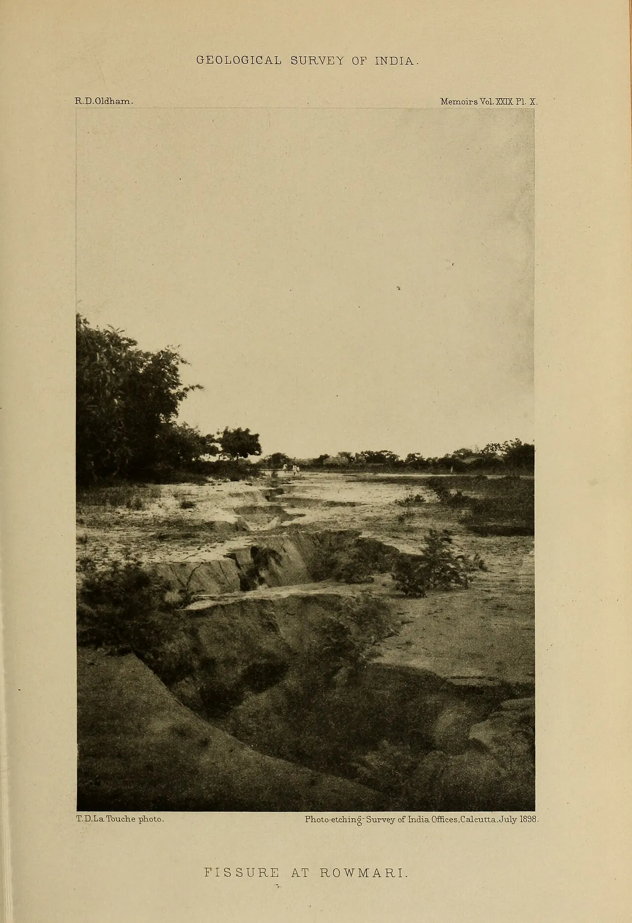
Rowmari, 1897: After the 1897 Shillong earthquake the ground at Rowmari split open into a long crack (fissure). The photo is from R. D. Oldham’s 1899 report on this earthquake.
Photo T. D. La Touche; R. D. Oldham (1899), Memoirs of the Geological Survey of India, vol. 29, plate X. Public domain. Image: Wikimedia Commons.

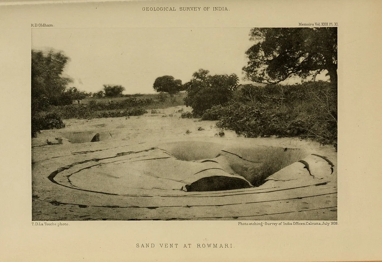
Rowmari, 1897: A sand vent. The shaking made wet sand underground flow like a liquid, which is called liquefaction, and it burst up to the surface with the water. There is a shallow hollow in the middle with low rings of sand around it.
Photo T. D. La Touche; R. D. Oldham (1899), Memoirs of the Geological Survey of India, vol. 29, plate XI. Public domain. Image: Wikimedia Commons.

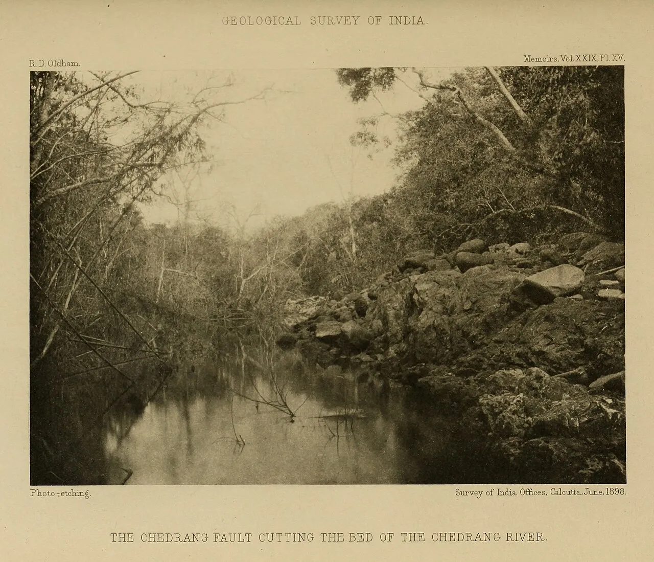
Chedrang River, 1897: In the 1897 earthquake the ground slipped along the Chedrang fault, and the fault cut across the bed of the Chedrang River. In a big earthquake a fault can break through to the surface.
R. D. Oldham (1899), Memoirs of the Geological Survey of India, vol. 29, plate XV. Public domain. Image: Wikimedia Commons.

A discovery that came out of India
R. D. Oldham worked for the Geological Survey of India. By reading the seismograms of the 1897 Shillong earthquake, he showed in 1900 that earthquake waves are of three kinds, which today we call P, S and surface waves. In 1906 he used these same waves to show that the Earth has a core at its centre.
Who keeps watch on earthquakes?
The National Centre for Seismology (NCS) of the Ministry of Earth Sciences runs 170 seismic observatories across the country. When an earthquake strikes, its location, depth and magnitude are worked out and posted on the NCS website and the BhooKamp mobile app, and sent to the states' disaster centres.
Checkpoint✓ Stop complete
1Which zone has the highest earthquake risk in India?
Zone V can expect the strongest shaking, as in the North-East, Kutch and the Andaman and Nicobar Islands. Zone II the least.
2On what day did the big Bhuj (Gujarat) earthquake strike?
On the morning of Republic Day, magnitude 7.7. 26 December 2004 is the day of the Sumatra earthquake and tsunami, and 15 August 1950 that of the Assam-Tibet earthquake.
3Which national body keeps watch on earthquakes in India?
The NCS of the Ministry of Earth Sciences runs seismic observatories across the country and issues information on every earthquake.
7Rajasthan and earthquakes
Rajasthan sits on an old, stable part of the Indian plate. The Aravallis are counted among the oldest mountain ranges in the world. So big earthquakes come here far less often than in the Himalayas or Kutch, and no part of the state is in Zone V.
But “less” does not mean “never”. The south-western corner next to Gujarat and some parts towards Alwar are in Zone IV. Kutch (Zone V) is next door, and big Himalayan earthquakes shake places far away. One more thing: many old houses in Rajasthan are built with heavy stone slabs laid on stone walls. If such a roof shakes hard, the slabs can slide and fall. Most lives are taken not by the earthquake itself but by falling roofs and walls.
| Zone | Where in Rajasthan |
|---|---|
| IV | The south-western corner on the Gujarat border (towards Barmer and Jalore), and north-eastern parts towards Alwar |
| III | A broad belt across the west and south-west: Jaisalmer, western Bikaner, Barmer, Jalore, Sirohi; and in the north-east, parts of Alwar and Bharatpur |
| II | The whole rest of the state, including the cities of Jaipur, Jodhpur, Ajmer, Kota and Udaipur |
See the BMTPC earthquake map of Rajasthan
Seismic band
If you build a new house, have a continuous band of concrete and steel bars laid along the walls: above the windows and doors (the lintel band) and just below the roof. This band ties all the walls together like a box, so that they do not fall separately when shaken. Rules like these are given in the Indian Standard IS 4326.
Stone-slab roofs
An old slab roof does not have to be torn down completely. If the girders or beams under the slabs rest properly in the walls and are tied to each other, the roof is safer. Ask an engineer for advice before starting any work.
Checkpoint✓ Stop complete
1No part of Rajasthan is in which zone?
Rajasthan lies in Zones II, III and IV. Zone V, the highest-risk zone, is not here, but it is in neighbouring Kutch.
2What does a seismic band do in a new house?
Without a band, walls can come apart from each other and fall when shaken. The band holds them together.
3Which job at home will help most before an earthquake?
Most injuries in an earthquake come from falling objects and breaking glass.
8Tsunamis
When a big earthquake strikes under the sea and the sea floor suddenly rises or sinks, all the water above it moves too. The train of waves this creates is called a tsunami; it is a Japanese word meaning “harbour wave”. Most tsunamis form at boundaries where one plate sinks beneath another.
In the deep ocean a tsunami wave is only a metre or so high, and people on a ship do not even notice it. But it is hundreds of kilometres long and travels as fast as an aeroplane. As it nears the coast and the water gets shallower, the wave slows down, and the water behind piles up onto it. So by the time it reaches the shore, the same wave has become a wall many metres high.
26 December 2004
The tsunami raised by the magnitude 9.1 earthquake near Sumatra reached many countries around the Indian Ocean. In India it caused heavy destruction on the Andaman and Nicobar Islands and along the coasts of Tamil Nadu, Puducherry, Andhra Pradesh and Kerala.
India's tsunami warning
The Indian Tsunami Early Warning Centre is at the Indian National Centre for Ocean Information Services (INCOIS) in Hyderabad. As soon as a big earthquake strikes under the sea, it works out whether a tsunami will form, and which coast it will reach and when.
If the sea pulls back, run
Before a tsunami the sea sometimes suddenly pulls far back from the shore. Do not go to look at it; go to high ground at once. A tsunami brings not one wave but several, and the first is not necessarily the biggest. If you feel a strong earthquake on the coast, go to high ground without waiting for a warning.
Checkpoint✓ Stop complete
1What usually causes a tsunami?
When the sea floor moves, all the water above it moves. Storm waves move only the water near the top, and the Moon causes the daily tides.
2About how fast does a tsunami travel in sea 4,000 metres deep?
Speed = √(9.8 × 4,000) ≈ 198 metres per second, that is about 713 kilometres per hour: as fast as an aeroplane.
3If the sea suddenly pulls far back from the shore, what should you do?
It can be a sign of an incoming tsunami. Several waves come, so stay on high ground until an official notice says the danger is over.
9Staying safe in an earthquake
An earthquake cannot be stopped, and nobody can tell its day and time in advance. But most of the harm it does can be prevented. Most people are hurt by falling walls, roofs, cupboards and glass. So two things matter most: houses should be built strong, and while the ground shakes we should know what to do.
The National Disaster Management Authority (NDMA) gives simple advice: Drop, cover and hold on. Practise it at home and at school until you know it by heart, so that even in a panic your body does the right thing by itself.
1 Drop
As soon as the ground shakes, get down on your knees. If you stay standing, you may fall.
2 Cover
Get under a strong table or bed. If there is nothing like that nearby, sit in a corner of an inside wall and cover your head and neck with your arms. Stay away from windows, glass and heavy cupboards.
3 Hold on
Hold on to a leg of the table, and if the table moves, move with it. Stay there until the shaking stops completely. Then go carefully outside to an open space, not by the lift.
Can earthquakes be predicted?
No. Today nobody in the world, no scientist and no organisation, can tell the day, time and place of an earthquake in advance. Scientists can only say how likely a big earthquake is in an area over the coming decades. Messages saying “an earthquake will strike on such-and-such a date” are rumours; do not forward them.
What is early warning?
It is not a prediction: the earthquake has already begun. Sensors near the epicentre catch the P wave, which arrives first, and a computer at once sends a message to faraway areas by phone or siren. A radio message travels far faster than the waves, so people far away get the news a few seconds before the slower, more damaging waves arrive. For people right next to the epicentre, there is almost no time left.
Stand in a doorway?
People used to say: in an earthquake, stand under a door frame. Use a doorway only if it is right next to you and you know for sure that it is strong and load-bearing. In most homes you cannot be sure of that, and a swinging door can also hurt you. So if there is a strong table or bed nearby, it is better to get under it.
Do animals know first?
There are many stories of animals behaving strangely before an earthquake. Some animals may sense the first P wave before we do, that is, just a few seconds before the strong shaking. But so far no method has been found to forecast an earthquake reliably by watching animals.
Checkpoint✓ Stop complete
1If the ground starts shaking while you are indoors, what should you do first?
Running while the ground shakes carries the highest risk of falling and of being hit by falling things.
2How does earthquake early warning work?
A warning goes out only once the earthquake has begun. The message travels faster than the waves, so people far away get a few seconds.
3If you are trapped under rubble, what should you do?
Tapping helps rescuers find you. A match can set leaking gas on fire, and shouting nonstop makes you breathe in dust.
10Check yourself
Checkpoint✓ Stop complete
1What did seismic waves tell us about the outer core?
S waves do not pass through the outer core, and an S wave cannot travel through liquid.
2About how big is the difference in energy between a magnitude 5 and a magnitude 7 earthquake?
About 32 times for each step, so for two steps 32 × 32 ≈ 1,000 times.
3At least how many stations do you need to find the epicentre?
One station gives only the distance, that is, one circle. Three circles meet at only one place.
4What does India's seismic zone map tell us?
A zone tells how strong the shaking there can be, so that houses are built to match. Nobody can tell when an earthquake will come.
5Which of these is true?
That is why strong houses and drop, cover and hold on are the best protection. Releasing as much energy as one magnitude 7 earthquake would take about 1,000 magnitude 5 earthquakes, so small earthquakes do not stop big ones.
Well done! You have finished all ten stops. Now you can explain to anyone why earthquakes happen, how they are measured, how great the risk is in different parts of India and Rajasthan, and what to do when an earthquake strikes.
Glossary
- Earthquake
- Shaking of the ground caused by rocks suddenly slipping inside the Earth.
- Crust
- The topmost, thin, solid layer of the Earth, on which we live.
- Mantle
- The thick, hot layer below the crust, down to about 2,900 kilometres; solid, but flowing slowly.
- Core
- The innermost part of the Earth, made of iron and nickel. The outer core is liquid, the inner core solid.
- Moho
- The boundary between the crust and the mantle, where the speed of seismic waves suddenly jumps.
- Lithosphere
- The crust and the cool, rigid part of the mantle below it, which together make up the plates.
- Tectonic plates
- Large and small pieces of the lithosphere that move a few centimetres a year.
- Ring of Fire
- The belt of plate boundaries around the Pacific Ocean, where many earthquakes happen and there are many volcanoes.
- Fault
- A crack in rock along which the blocks on either side have moved relative to each other.
- Focus (hypocentre)
- The place inside the Earth where the rocks begin to slip in an earthquake.
- Epicentre
- The place on the Earth's surface directly above the focus.
- Elastic rebound
- Stress building up on a fault for years, then let go when the rocks suddenly slip.
- Seismic waves
- The waves that carry an earthquake's energy in all directions: body waves (P and S) and surface waves.
- P wave (primary wave)
- The fastest seismic wave, which squeezes and stretches rock along its direction; travels through solids, liquids and gases.
- S wave (secondary wave)
- The wave that arrives after the P wave and shakes rock across its direction; travels only through solids.
- Surface waves
- The slowest waves, Love and Rayleigh, which travel along the surface and do the most damage.
- Shadow zone
- The band 104° to 140° from an earthquake where no direct P waves are recorded.
- Seismograph and seismogram
- The machine that records the shaking of the ground, and the line it draws.
- Magnitude
- A measure of how much energy an earthquake released at its source. One step up means about 32 times the energy.
- Intensity
- A measure of how strongly the ground shook at one particular place and what effect it had there.
- Aftershock
- A smaller shock in the same area after a big earthquake.
- Liquefaction
- Waterlogged sandy ground flowing like water for a while during strong shaking.
- Seismic zone
- A division of the country's regions for building rules, according to how strong the shaking there can be.
- Seismic band
- A continuous band of concrete and steel bars along the walls, which ties all the walls together.
- Tsunami
- A train of very long waves made when the sea floor suddenly moves.
- Early warning
- A message sent to faraway areas as soon as an earthquake begins, a few seconds before the strong shaking reaches them.